A Glimpse of History in Benin City
Benin City, located in Nigeria, is a rapidly growing urban center, much like many other cities in the country. Over the past forty years, its population has increased by 1.7 million people, driven by expanding industrial and agricultural activities. As the city’s physical size has grown significantly, new roads, residential areas, markets, and workshops have emerged, transforming the landscape of this West African city.
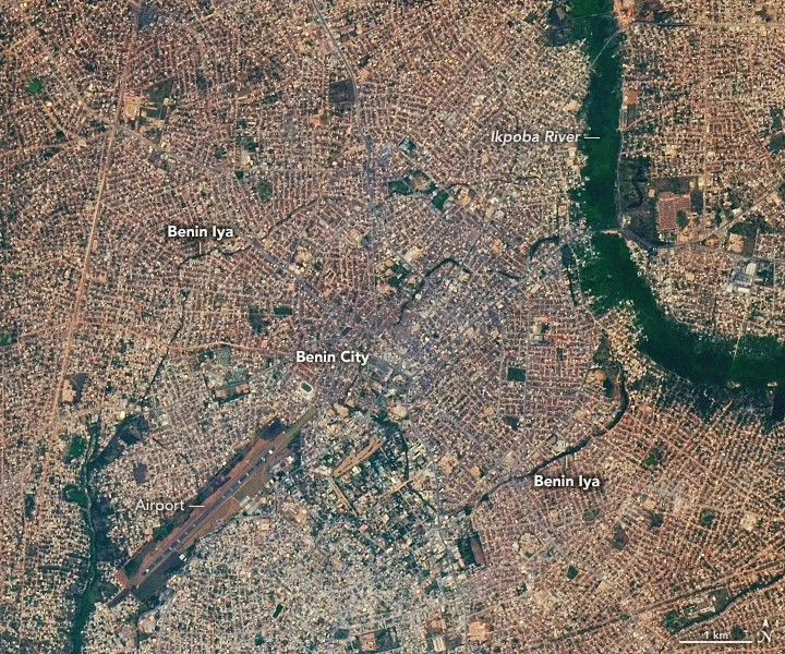
Despite this rapid development, Benin City still holds a glimpse of history within its modern boundaries. The city was once the capital of a powerful pre-colonial kingdom, and remnants of this ancient past remain visible today. Among the most remarkable historical features are the Benin Iya, also known as the Benin Earthworks, the Walls of Benin, or the Benin Moat. These earthworks are an extensive network of interlocking earthen walls, ramparts, and ditches that spread outward from a central moat located in the heart of the city.
The Ancient Earthworks: A Glimpse of History in Benin City
The Benin Iya was constructed over several centuries, between the 7th and 14th centuries. This vast system served multiple important functions in the Kingdom of Benin. It marked defensive boundaries, political territories, and economic zones, playing a crucial role in maintaining order and stability within the kingdom. The earthworks were not just simple walls; they formed a complex, cellular network that defined the city’s structure and governance.
On January 11, 2025, the Operational Land Imager-2 (OLI-2) on the Landsat 9 satellite captured an image of the remaining earthworks. These features appear as dark green lines tracing curved patterns in a densely populated area near the airport on the west bank of the Ikpoba River. The dark green color comes from trees and vegetation growing in the moats, making the ancient structures visible from space.
Most sections of the earthworks consisted of narrow and shallow linear ramparts and ditches that extended widely across the landscape. Many parts have been destroyed or obscured by modern urban development, making them difficult to detect from orbit. However, some inner sections, especially those passing through the modern districts of Oredo, Egor, and Ikpoba-Okha, still have true walls and moats. These sections are among the most visible in satellite images.
The Scale and Significance of the Benin Earthworks
Archaeological studies reveal that the Benin earthworks once stretched over 16,000 kilometers (10,000 miles) and enclosed an area of approximately 6,500 square kilometers (2,500 square miles). This area is comparable in size to the U.S. state of Delaware. The sheer length of these earthworks has earned them a Guinness World Record as the “longest earthworks of the pre-mechanical era.”
In fact, by some measures, the combined length of the Benin earthworks surpasses that of the Great Wall of China. This highlights the extraordinary scale and engineering achievement of the Kingdom of Benin’s ancient builders. The earthworks not only served practical purposes but also symbolized the power and organization of the kingdom.
Today, the Benin earthworks remain a testament to the city’s rich historical legacy. They provide a unique glimpse of history in Benin City, linking the modern metropolis to its ancient roots. Despite the rapid urban growth and modernization, these earthworks continue to tell the story of a once-mighty kingdom that shaped the region’s cultural and political landscape.
The preservation and study of these earthworks are important for understanding the history and heritage of Benin City. As satellite technology advances, it allows researchers to observe and analyze these ancient structures from space, offering new insights into their extent and condition. The Benin earthworks stand as a remarkable example of human ingenuity and the enduring legacy of pre-colonial African civilizations.
For more stories on this topic, visit our category page.
Source: original article.